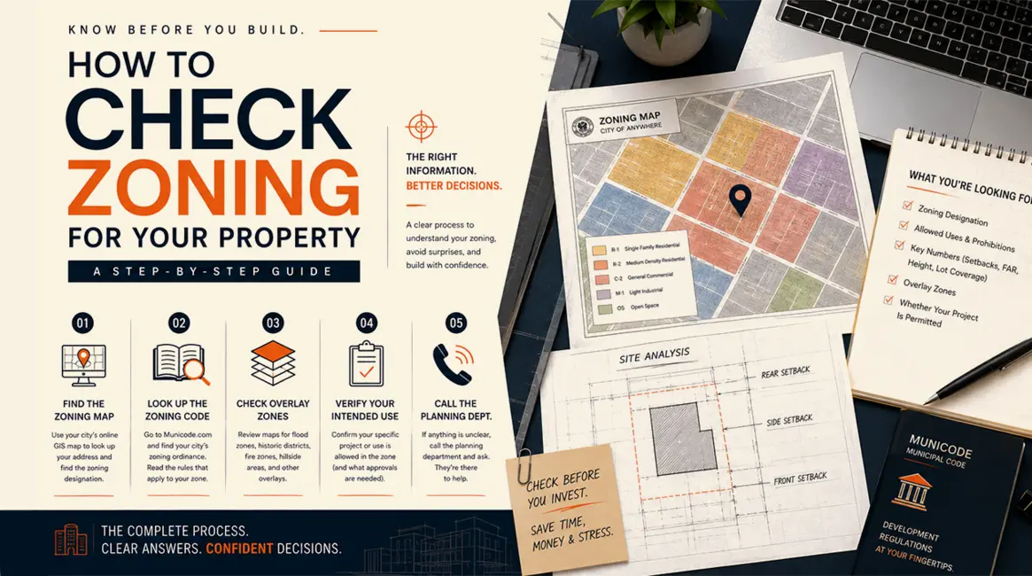
How to Check Zoning for Your Property, A Step-by-Step Guide
You have an address. You want to know what the zoning is. Right now, today. Maybe you're about to make an offer on a property and you want to know what you can build there before you commit. Maybe you already own the property and you're trying to figure out whether your an ADU permit package idea is even possible. Maybe a contractor mentioned that "zoning might be an issue" and you want to know what that actually means for your specific lot.
Whatever the reason, this is a process you can do yourself, and it's not as complicated as it sounds, once you know the steps and the tools.
Here's the complete path: find your city's online GIS zoning map and look up your address to get your zoning designation (something like R-1 or C-2). Then look up that designation in your city's zoning code on Municode.com to find out what it allows and what the key numbers are, setbacks, height limits, FAR, lot coverage. Then check for overlay zones like flood zones or historic districts. Then verify your specific intended use is allowed. Then, if anything is unclear, call the planning department. That's the complete process, and the rest of this article walks you through each step with the specific tools and the specific questions to ask.
What You're Looking For
Before you start clicking around, know what you're trying to find out by the end:
Your property's zoning designation (R-1, C-2, M-1, etc.) What that designation allows and prohibits for your intended use The key development numbers: setbacks, FAR, height limit, lot coverage Whether any overlay zones apply (flood, historic, fire, hillside) Whether your specific project is permitted
The most important thing to understand upfront: finding the zoning designation is only step one. A lot of people search their address, see "R-1," and think they're done. They're not. "R-1" is just a label, a label that means different things in every city. "R-1" in Los Angeles and "R-1" in Austin are different regulations entirely. The designation tells you which set of rules applies. Step two is finding out what those rules actually say.
To start, it helps to have:
Your property's exact address, the city or county that governs the property (usually obvious, but occasionally properties near jurisdictional boundaries need a quick check), and optionally an APN (Assessor's Parcel Number). The APN is on your property tax bill, on the county assessor's website, or on your title report, it's the unique identifier for your specific parcel and makes searches faster and more accurate. Not required, but useful.
Step 1, Find Your City's Zoning Map
Most cities now have an online interactive GIS zoning map where you can type in an address and see what zone the property falls in, color-coded on a map. These are free, publicly available, and usually accurate.
Four ways to find your city's zoning map:
Google search. The fastest starting point. Search "city name zoning map" or "city name GIS zoning." Click on official city or county government results, not real estate sites, not third-party aggregators. You want the actual planning or GIS department page. If the first result takes you to an interactive map where you can click on parcels, you're in the right place.
City website directly. Go to the official city website (usually cityofname.gov or just city.gov). Navigate to the planning department or community development department. Look for "zoning map," "GIS," or "interactive map." Most city planning department homepages link to their zoning map prominently.
County assessor website. Many county assessor sites let you look up a parcel by address and will show zoning information in the parcel details. It's not always complete, but it's a quick way to confirm a designation if you're having trouble finding the city's map.
Call the planning department. If online tools aren't working or you find the maps confusing, simply call the city planning counter and ask: "What is the zoning for address?" This is public information and they'll tell you immediately. The planning counter number is almost always listed on the city's planning department page.
What you'll see on the map: a color-coded area where each color represents a different zoning designation. Click on your parcel and a popup usually shows the designation, something like "R-1 SF" (single-family residential) or "C-2" (general commercial) or "M-1" (light industrial).
Write down or screenshot: the exact designation, which city governs the property, and the date (zoning codes change).
One important note: if you're looking at a property near a city boundary, confirm which jurisdiction actually governs the parcel. Some properties sit in unincorporated county territory even when they have a city mailing address, and the county's zoning rules are different from the city's.
Step 2, Find the Zoning Code for Your Designation
Now that you have a designation, you need to find out what it actually means. Your destination is your city's zoning ordinance, which lives in the municipal code.
The fastest tool: Municode.com. Most US cities and counties publish their municipal codes on Municode.com, and it's completely free to read with no account required. Go to municode.com, click "Library," and search for your city. You'll find a searchable, organized version of their entire municipal code. Navigate to the zoning chapter, it's usually titled something like Title 17, Title 18, or Title 21, depending on the city, and then find the section covering your specific zoning designation.
If Municode doesn't have your city, try American Legal Publishing at amlegal.com, a similar resource hosting many additional city codes. Or go directly to the city's planning department website and look for "municipal code," "zoning code," or "development code", many cities either host their code directly or link to Municode from there.
Once you're in the code, use Ctrl+F to search for your designation. Search "R-1" or "C-2" or whatever your designation is. You'll land in the section defining that zone.
What you're looking for in that section:
Permitted uses, what can go on this property without any special approval. Single-family dwelling, park, school, etc. This is where you'll see whether your intended use is on the list.
Conditional uses, uses allowed only with a Conditional Use Permit (CUP), which requires an application and approval process.
Development standards, this is often presented as a table, which is easier to read than the surrounding paragraph text. Look for:
- Minimum lot size - Front yard setback (minimum feet from front property line) - Rear yard setback (minimum feet from rear property line) - Interior side yard setbacks (minimum feet from side property lines) - Street side yard setback (for corner lots, the side facing a street) - Maximum building height (in feet or stories) - Maximum FAR (floor area ratio, total floor area relative to lot size) - Maximum lot coverage (what percentage of the lot can be covered by buildings) - Parking requirements
Record all of these numbers. They're what you'll need to determine whether your project fits.
Here's roughly what a zone section looks like: the designation name and a brief description, a list of permitted and conditional uses, and then a development standards table with all the numbers. The table is usually the most useful part.
Step 3, Check for Overlay Zones
This is the step most people skip, and it's where expensive surprises often come from.
Overlay zones are additional regulations layered on top of the base zoning, applying to specific geographic areas. Your property might be in a perfectly ordinary R-1 zone AND in a historic preservation overlay district that requires design review board approval for any exterior changes. Or it might be in a flood zone that requires significantly different (and more expensive) construction. Base zoning alone doesn't tell you this.
Common overlay zones and how to check each:
| Overlay Type | What It Means | How to Check | Key Impact |
|---|---|---|---|
| Historic district | Design review required; may limit demolition | City GIS map (turn on historic layer); city historic preservation office | Specific materials, design standards, additional approval process |
| FEMA flood zone | Elevated construction may be required | msc.fema.gov, enter address to see flood zone | Significantly higher construction cost; mandatory flood insurance |
| Wildfire hazard (FHSZ) | Fire-resistant materials required | Cal Fire website (California); state fire agency for other states | Material restrictions, defensible space requirements |
| Hillside overlay | Additional grading and stability restrictions | City GIS map; planning department | Lower lot coverage, stricter setbacks, grading permits |
| Airport overlay | Height restrictions near flight paths | FAA obstruction charts; city planning | May prevent taller structures |
| Coastal zone | Coastal Commission review required | coastal.ca.gov (California); state coastal agency elsewhere | Additional permitting layer, restricted development near coast |
To check overlays on the GIS map: many city zoning maps have multiple layers you can toggle on and off. Look for a layers panel or legend, you may see options for historic districts, flood zones, fire hazard areas, and more. Toggle them on and check whether your property falls within any of them.
The FEMA flood map is worth checking separately even if the city GIS doesn't show it clearly. Go to msc.fema.gov, enter the address, and you'll see the flood zone designation. Zone X means minimal flood risk. Zone AE or A means you're in the 100-year floodplain, which triggers elevated construction requirements and mandatory flood insurance, both significant cost factors.
If you find an overlay applies, dig into what it requires. The city planning department is usually the right contact for historic and hillside overlays; FEMA documentation covers flood zones; state agencies cover wildfire and coastal overlays.
Step 4, Check Your Intended Use Is Allowed
With the base zone rules and overlays identified, now verify that your specific project is actually permitted.
For an ADU: Look for ADU provisions in the local code, many cities have a dedicated ADU chapter. Check minimum lot size (if any), maximum ADU size, required setbacks for the ADU (which may differ from the main structure), and parking requirements. If you're in California, understand that state law often overrides more restrictive local provisions, see Step 5.
For a commercial use: Find the use table in the zoning code. This is usually a grid with uses listed down one side and zone designations across the top. Find your intended use type (restaurant, office, retail, medical) and see whether it's marked as permitted (P), conditional (C, needs a Conditional Use Permit), or not allowed (–). If conditional, the CUP process typically takes three to six months and involves a planning board hearing.
For an addition to a residential building: additions in residential zones are generally permitted by right, without special approval, as long as they comply with all the development standards, setbacks, FAR, lot coverage, height. No use question here, just making sure the design fits within the numbers.
For a change of use on a commercial property: check the use table for your intended business type in that zone. Also compare parking requirements between the old use and the new one, changing from an office (lower parking requirement) to a restaurant (higher parking requirement) may create a parking shortfall that affects feasibility.
Step 5, Understand State Law Overrides
This step is critical in California and growing in importance in other states, and it's one the most experienced DIY researchers often don't know to check.
State housing laws increasingly override local zoning restrictions. In California specifically, a series of state laws now require cities to allow ADUs even when local zoning would otherwise prohibit them, and SB 9 allows duplexes and lot splits on single-family lots statewide regardless of what local R-1 zoning says. If you're in California and the local code says "no ADU" or "single-family only," state law may give you rights the local code doesn't acknowledge.
For ADUs in California: if your local code appears to prohibit or heavily restrict an ADU, check the California Department of Housing and Community Development (hcd.ca.gov). Their ADU resources explain what cities are and aren't allowed to restrict. The short version: most California cities must allow at least one attached ADU and one junior ADU on single-family lots, and most must allow one detached ADU as well, subject to state minimum standards.
For SB 9 in California: if you're on an urban single-family lot and want to build a duplex or split the lot, SB 9 may apply regardless of local zoning. The state law requires ministerial approval, meaning the city generally can't deny a compliant application.
In other states: Oregon, Washington, Montana, Massachusetts, and others have passed state housing laws that similarly preempt local restrictions in certain situations. Check your state's housing agency website if you're hitting what seems like an unusual local restriction.
The practical upshot: don't treat local zoning code as the final word, especially in California. If the local code says no and you're wondering whether that's actually true, a quick check of applicable state law is worth the time.
Step 6, Verify With the Planning Department
After completing your own research, verify your conclusions with the city.
Why: zoning codes are updated regularly, and the version online may lag behind recent amendments. Your interpretation of ambiguous code language might be wrong. Overlay zones might not be clearly visible on the GIS map. Planning staff can confirm, clarify, and catch anything you missed.
How to reach them: the planning counter, reachable by phone or in person, is usually the most responsive. Email is slower but creates a written record. For complex projects, a pre-application meeting is a more formal option that gets you documented answers.
What to say: > "I'm planning to describe your project at address. The property appears to be zoned designation. Can you confirm that zoning and let me know whether my project would be allowed?"
Keep it specific. The more clearly you describe what you want to do, the more useful their answer.
Get it in writing when you can. An email confirmation from planning staff is much more useful than a phone conversation with no record. For anything significant, ask if they can confirm their answer by email. Some cities offer formal zoning verification letters, worth asking about for larger projects.
What to Do With What You Find
If your project is allowed outright: you know the constraints. Proceed to design with those parameters as your guide, setbacks, FAR, height, coverage, so the drawings your drafter creates will pass plan check without a redesign.
If your project needs a Conditional Use Permit or variance: evaluate whether to pursue it. A CUP typically takes three to six months and involves public notice and a planning board hearing. A variance requires demonstrating hardship, generally related to the property's physical characteristics, not just a desire for more space. Both are legitimate paths, but neither is guaranteed. Research whether similar approvals have been granted nearby, and assess your timeline and appetite for an uncertain process.
If your project isn't allowed: don't panic. Options include modifying the project to fit within what is allowed, pursuing a variance on hardship grounds, checking whether state law overrides the local restriction, or, if this was pre-purchase research, choosing a different property. Knowing you can't do what you planned before you've spent money on design is far less painful than finding out after.
When to Hire a Professional
DIY is fine when: you just want a quick preliminary check, you're dealing with a simple property in a city with clear online tools, the project is relatively small and low-stakes, and you have the patience to read through a municipal code.
Hire a professional when: the project investment exceeds $50,000, the property is in a commercial zone (more complex regulations), you've found overlay zones you don't fully understand, you're in California and think state law might override local restrictions, you want a written report rather than your own notes, or you need confidence to share with a lender or business partner.
| DIY | Professional | |
|---|---|---|
| Cost | Free (your time: 3–6 hours) | $500–$2,000 |
| Zoning designation | Yes, findable | Yes, confirmed |
| Overlay zones | Often missed | Systematically checked |
| State law overrides | Often unknown | Included |
| Planning department verification | Optional | Often included |
| Written report | No (just notes) | Yes |
| Best for | Quick check, low-stakes | $50k+ project, commercial, overlays |
Professional zoning research typically delivers a written report covering the designation, all development standards, any applicable overlay zones, state law comparison, planning department confirmation, and a clear recommendation for next steps.
Zoning Lookup Tools and Resources
| Tool | What It Does | Cost | Best For |
|---|---|---|---|
| Municode.com | Full text of most US city municipal codes | Free | Reading your specific zoning code |
| amlegal.com | Alternative to Municode (many cities) | Free | Cities not on Municode |
| msc.fema.gov | FEMA flood zone maps for any US address | Free | Checking flood zone status |
| regrid.com | Parcel data and zoning by address | Basic: free; more: paid | Quick zoning lookup before finding city map |
| Your city's GIS portal | Official interactive zoning map | Free | Confirming zone and checking overlay layers |
| County assessor website | Parcel details including sometimes zoning | Free | Finding APN; basic parcel info |
California-specific: California HCD (hcd.ca.gov) for state ADU law guidance; Cal Fire FHSZ maps at osfm.fire.ca.gov for wildfire hazard zones; the California Coastal Commission at coastal.ca.gov for coastal zone information. For LA specifically, the ZIMAS tool at zimas.lacity.org is an excellent GIS portal.
On Regrid: enter your address at regrid.com and you'll see parcel information including a zoning designation in many cases. It's a useful quick-check tool, though you should always confirm with the official city source before making any decisions.
Common Questions About Checking Zoning
How do I find my property's zoning? Go to your city's official website, navigate to the planning department, and find the online GIS zoning map. Enter the address and the map will show your zoning designation. If you can't find the map online, call the city planning counter and ask.
What website do I use to check zoning? Start with your city's own GIS zoning map (find it via your city's website). Then use Municode.com to read the actual rules for your zone designation. Use msc.fema.gov to check flood zones.
What does my zoning designation mean? The designation is a label, R-1, C-2, M-1, pointing you to a set of rules in your city's zoning code. Look up that designation in your city's code on Municode.com to find what's allowed, required setbacks, height limits, and other development standards.
How do I read a zoning code? Search for your designation using Ctrl+F on Municode. Look for the development standards table, it's usually easier to read than paragraph text. You're looking for: permitted uses, setbacks (front, rear, side), height limit, FAR, and lot coverage.
What if I can't find my city's zoning map online? Call the planning counter. Ask: "What is the zoning for address?" It's public information and they'll tell you immediately. You can also try the county assessor's website as a backup.
What are overlay zones and how do I check them? Overlay zones are additional rules layered on top of base zoning, historic districts, flood zones, fire hazard areas, hillside overlays. Check the city GIS map (toggle on overlay layers), check msc.fema.gov for flood zones, and call the planning department to ask specifically about any overlay zones affecting the property.
Does state law override local zoning? Sometimes yes, especially in California for ADUs and SB 9 situations. If a local code seems to prohibit something you believe state law should allow, check the state housing agency's guidance. Don't treat local code as the final word without checking whether state law changes the picture.
Can the planning department tell me my zoning? Yes, call and ask. It's public information and staff are generally helpful in confirming designations and explaining basic rules. For complex questions, ask about a pre-application meeting.
How long does it take to check zoning yourself? Finding the designation: 10–20 minutes. Reading the zoning code and recording the development standards: another 30–60 minutes. Checking overlay zones: 30–60 minutes. Calling the planning department for confirmation: variable. Total: 2–3 hours for a thorough DIY check.
When should I hire someone to check zoning for me? When the project is over $50,000, the property is commercial, you've found overlay zones you don't fully understand, you're in a state where recent housing laws may override local rules, or you want a professional written report rather than personal notes.
---
Checking zoning yourself is genuinely doable, and following these steps will get you most of the way there on most properties. The places where DIY tends to fall short are overlay zones (easy to miss if you don't know to look), state law overrides (not obvious from the local code), and ambiguous code language that reads one way but means another in practice.
For any project worth significant money, professional zoning research, a complete check with a written report and planning department confirmation, is inexpensive insurance. Cadtri handles this as the first step of every project, so that when you move into design and drawings, you're already working with confirmed knowledge of what's possible.
---
Related reading: What Is Zoning Research? · Setbacks, FAR, and Lot Coverage · What Is a Zoning Variance? · Feasibility vs Full Design · What Is a Zoning Clearance? · Ministerial vs. Discretionary Review · California ADU Laws 2026 · Zoning Research Services · Permit Drawing Services